Envision.
Build.
Sustain.

Planning for an Integrated, Resilient Future

Logo background

Yolo Bypass Cache Slough Partnership

A Vision for a New Era

CA Senate Bill 369 directed Partnership agencies to work in collaboration to advance the following objectives:

  • Prioritize projects that accommodate multiple objectives in the YBCS region.
  • Identify project implementation challenges and work collaboratively to resolve those challenges.
  • Develop programmatic and expedited approaches for regulatory compliance. Identify funding mechanisms for project implementation and long-term operations and maintenance.
  • Develop strategies to foster regional agricultural sustainability, recreational opportunities, and long-term water supply reliability.

Yolo Bypass Cache Slough Partnership

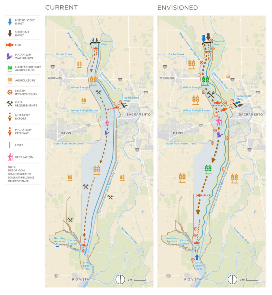
The Yolo Bypass Cache Slough Partnership is a dynamic and results-focused response to those challenges. Local, state, and federal agency members of the Partnership – working closely with regional agencies, interested parties, and Native American Tribes – are jointly planning and implementing projects capable of delivering multiple benefits across a shared YBCS landscape. Flood risk management, fisheries and wildlife habitat, water supply, water quality, agriculture, and recreation – collectively referred to as the Partnership Pillars – are all central to collaborative planning for a vibrant future for the region’s residents, businesses, and ecosystem. Further, the Partnership is committed to making diversity, equity, and inclusion central to its efforts to accrue benefits across these pillars.

Yolo Bypass Cache Slough Region

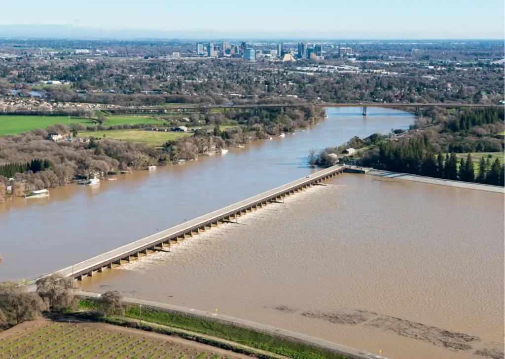
The Yolo Bypass is a 40-mile long, 59,000 acre federal flood management facility, built in the 1930s to protect lives and property across the Sacramento metropolitan area.

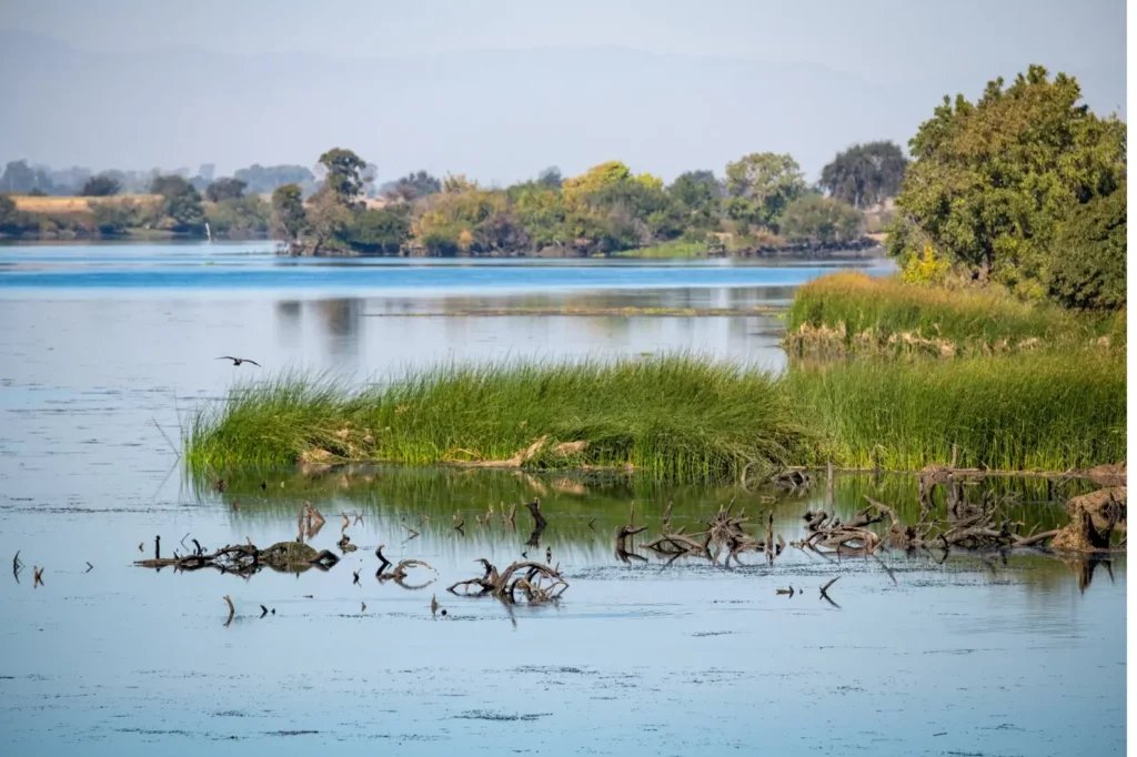
The Cache Slough is located primarily within the County of Solano, intersecting with the southern portion of the Yolo Bypass. Cache Slough supports remnant tidal habitat where restoration of natural conditions could benefit delta smelt and other native aquatic species. Cache Slough is also a regionally significant agricultural area where the location of multiple-benefit projects could affect the operations and maintenance practices of agricultural diverters and core flood control and levee maintenance responsibilities of reclamation districts within the Cache Slough Complex.

Together, the Yolo Bypass and Cache Slough region presents unparalleled opportunities for multiple-benefit projects that improve flood protection, fisheries and wildlife habitat, water supply and water quality, agriculture, and recreational opportunities. As such, the Yolo Bypass and Cache Slough region is the focus of an increasing number of federal, state, and locally developed projects intended to improve these multiple public values. 

Today, the Yolo Bypass Cache Slough region (YBCS) is a microcosm of challenges and opportunities facing water managers and planners around California. Climate change is increasing the frequency and intensity of floods and droughts in the YBCS, adversely impacting the region.

Vision

The local, state, and federal agency members of the Partnership – working closely with other agencies, interested parties, and Native American Tribes – are jointly planning and implementing projects capable of delivering multiple benefits across a shared YBCS landscape.

Partnership Goals

In recognition of the advantages of an integrated approach, a new era of multi-benefit collaborative planning began in 2016 when representatives of 15 agencies executed the Yolo Bypass Cache Slough Partnership Memorandum of Understanding. Since 2016, the Partner agencies have been developing a Program that encourages collaboration on regional solutions to implement landscape-level change.

The success of the Partnership will require proactive investment, leveraging of resources, and sustainable funding mechanisms for Partnership activities and long-term management of the YBCS system and its features.

Flood Icon

Flood

checkmarkExpand the flood conveyance capacity of the YBCS System, to include investments in local communities’ measures to meet existing and future flood risk management standards.
checkmarkEstablish a more predictable regulatory and funding framework to enable effective, affordable, and sustainable operations and maintenance of a flood risk management system that accommodates other Partnership goals.
Agriculture Icon

Agriculture

checkmarkPromote good neighbor policies through active engagement with agricultural interests to incorporate resilient agricultural measures in the full lifecycle of projects.
checkmarkFoster resiliency by preserving agriculture’s physical and economic viability in response to competing land uses and climate change.
checkmarkDevelop a planning framework and funding mechanisms to protect and support agriculture.
Habitat Icon

Habitat

checkmarkImprove habitat quality and quantity to achieve multiple benefits for ecosystems.
checkmarkAlign ecological improvements and environmental sustainability with existing and future land uses.
checkmarkImprove permitting efficiency of multi-benefit projects.
Water Supply Icon

Water Supply

checkmarkPreserve continued access to cost effective and resilient water supplies in the YBCS for local agriculture and regional municipal users.
checkmarkPursue a multi-benefit solution that improves the regional water supply resilience of facilities such as the North Bay Aqueduct and also protects and enhances investments in fisheries and habitat resources.
Recreation Icon

Recreation

checkmarkResponsibly improve recreational access and amenities in the YBCS Region by building on existing multi-benefit planning efforts while respecting existing land uses and owners.
checkmarkImprove tourism opportunities and grow community appreciation, knowledge, and support for the YBCS Region.
checkmarkEnsure long-term operations and maintenance requirements for recreational amenities are included in planning efforts.
Water Quality Icon

Water Quality

checkmarkMinimize discharge and production of toxic contaminants into the YBCS, starting with methylmercury.
checkmarkImprove drinking water quality by reducing the impacts of increased organic carbon and bromide in Cache Slough source water and submerged aquatic vegetation near drinking water intakes in the Cache Slough Complex.

Understanding the Importance of the YBCS Region

Flood: Yolo Bypass conveys 80% of Sacramento River watershed flows during floods, reducing risk to $68 billion in property and 650,000 people in the Sacramento Metropolitan area.
Agriculture: Agricultural land within and protected by the Yolo Bypass supports the local and state economy, provides wildlife habitat, and functions as part of the flood protection system. Approximately 268,000 acres of productive farmland in Solano, Yolo, and Sacramento Counties, approximately 47,000 acres of that within the YBCS, contribute to California’s economic engine.
Habitat: ­The Region is a mosaic of managed wetlands of international importance in the heart of the Pacic Flyway, serving millions of migratory waterfowl and shorebirds each year. ­The 16,800-acre Yolo Bypass Wildlife Area provides critical habitat for over 200 avian species, and the Fremont Weir Wildlife Area provides grassland and riparian habitat. ­is corridor also supports a range of endangered or threatened terrestrial and aquatic species and protects them through conservation easements held over private lands.
Water Supply: Numerous habitat restoration projects in the YBCS mitigate for the continued operation of the State Water and Central Valley Projects, which provide drinking water to 25 million Californians and irrigation to 4.5 million acres of agricultural land. The North Bay Aqueduct, a decentralized component of the State Water Project, delivers drinking water from Cache Slough to over 500,000 residents in Napa and Solano Counties.
Water Quality: Efforts on Cache Creek, a tributary to the YBCS, represent an opportunity to reduce mercury inputs to the Bay Delta system.
Recreation: The YBCS provides local and regional recreation and tourism opportunities, including the Great California Delta Trail, sport fishing, hunting, wine tasting, boating, and exploring the nearly 16,000-acre Yolo Bypass Wildlife Area, which also provides unique environmental education programs.

Centered between the Sacramento and American Rivers and the Sacramento-San Joaquin Delta, the YBCS is the heart of a vast watershed – and central to a robust regional agricultural economy, reliable water supply, and resilient ecosystem, in addition to flood risk reduction.

Partners

In recognition of the advantages of an integrated approach, a new era of multi-benefit collaborative planning began when local, state and federal agency representatives executed the YBCS Memorandum of Understanding. In September 2021, SB 369 added the West Sacramento Area Flood Control Agency.

California Department of Fish and Wildlife
California Department of Water Resources
California Natural Resources Agency
Central Valley Flood Protection Board
Central Valley Regional Water Quality Control Board
County of Solano
County of Yolo
Reclamation District No. 2068
Sacramento Area Flood Control Agency
Solano County Water Agency
State Water Resources Control Board
U.S. Army Corps of Engineers
U.S. Bureau of Reclamation
U.S. Fish and Wildlife Service
U.S. National Marine Fisheries Service
(West Sacramento Area Flood Control Agency)